
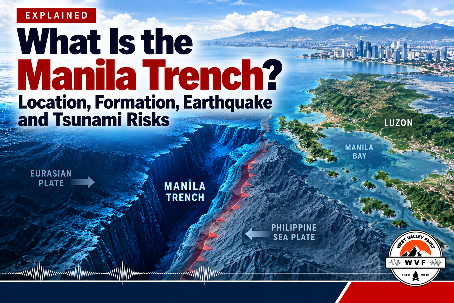
Off the western coast of Luzon, a deep submarine trench marks one of the Philippines’ important earthquake-generating plate boundaries. The Manila Trench is not visible from shore, yet the movement of rock beneath it matters to communities bordering the West Philippine Sea and the wider South China Sea. It can generate offshore earthquakes and, under certain conditions, tsunamis. Understanding why is more useful than treating every cluster of tremors as a warning of an imminent disaster.
This guide explains where the trench lies, how subduction works, what scientists know about its hazards, and what remains uncertain. It also explains why the Manila Trench and the West Valley Fault must not be confused. Earthquakes and tsunamis cannot be forecast to a precise date from ordinary patterns of recent shaking.

What is the Manila Trench?
The Manila Trench is a long, deep depression in the seafloor on the eastern side of the South China Sea, west of the Philippine island of Luzon. It is the surface expression of an active subduction zone: a boundary where one tectonic plate moves beneath another and descends into the Earth. It belongs to the Philippines’ complex network of trenches, faults and volcanic arcs.
A trench is not simply a crack in the seabed. It marks part of a much larger geological system. The associated megathrust is an inclined fault interface at depth where the descending plate and the overlying plate meet. Earthquakes can occur on this interface or within either plate. Whether a particular earthquake generates a tsunami depends on its mechanism, depth, size and effect on the seafloor, among other factors.
Where is the Manila Trench located?
The trench runs roughly north–south offshore of western and northwestern Luzon, extending toward southern Taiwan at its northern end and the complicated tectonic boundaries around southwestern Luzon and Mindoro to the south. The adjacent sea is part of the South China Sea, called the West Philippine Sea in Philippine geographic and public usage for waters west of the archipelago.
It lies well offshore rather than beneath Metro Manila’s streets. Coastal areas of western Luzon face the trench across the sea; inland communities may experience earthquake shaking from an offshore event, but tsunami exposure is primarily a concern for vulnerable coastal locations. Local exposure varies greatly with coastal elevation, shoreline shape, water depth, river mouths, bays and officially mapped inundation zones.
For authoritative geographic context, see the DOST-PHIVOLCS Philippine Trenches mapping service. It identifies the Manila Trench among the country’s major subduction-related structures. A trustworthy map should distinguish its offshore location from faults plotted on land.

How was the Manila Trench formed?
Earth’s outer shell is divided into moving tectonic plates. West of Luzon, crust associated with the South China Sea portion of the Sunda/Eurasian plate system converges with the Philippine Mobile Belt. In simplified terms, the western plate descends eastward beneath the Luzon region. As that crust bends downward, a deep ocean-floor depression forms: the Manila Trench.
Subduction has operated over millions of years. Sediment and rock can be scraped, compressed or carried downward, while deformation builds in the overlying crust. The larger tectonic system also contributes to the geological development of Luzon’s volcanic arc. This is a slow process measured in geological time, not an opening or widening crack that appears suddenly during a present-day earthquake.
Descriptions of the plates sometimes differ because the Philippine Mobile Belt is a complex collection of blocks between larger plates. Scientists also distinguish the southern and northern portions of the subduction system; its structure is not uniform along its entire length. The important point for readers is the direction of convergence and the existence of a potentially locked offshore fault interface.

Why does the Manila Trench generate earthquakes?
Tectonic plates continue moving even when sections of their boundary resist sliding. Where the megathrust is strongly coupled or ‘locked,’ elastic strain may accumulate. If resistance is overcome, the fault can slip abruptly and release energy as an earthquake. Other earthquakes may arise from bending and fracturing inside the descending plate or from faults in the upper plate.
The amount of shaking felt on land is not determined by magnitude alone. Earthquake depth, distance, local soil conditions and building characteristics matter. An offshore magnitude 5 earthquake may be noticeable in some communities and barely felt in others. A much larger rupture could affect a wider region, but its exact effects would still depend on the event.
Not every earthquake plotted near the trench necessarily ruptured its main megathrust. Scientists use locations, depths, faulting mechanisms and seismic-wave analyses to identify probable sources. That distinction is essential when interpreting news headlines about multiple earthquakes in the same marine area.
WVF previously covered 152 earthquakes along the Manila Trench and what PHIVOLCS did—and did not—conclude. A sequence of earthquakes does not, by itself, establish that a larger earthquake is imminent. Monitoring can describe activity, but there is no scientifically reliable method to predict the exact time, location and magnitude of a future major earthquake.
Can the Manila Trench produce a major tsunami?
Yes, it is a credible tsunami source. A large offshore earthquake can generate a tsunami when fault movement rapidly displaces a significant volume of seawater, particularly through vertical seafloor motion. A submarine landslide can also generate local tsunami waves. Yet not every offshore earthquake, including some very strong ones, produces a damaging tsunami.
Peer-reviewed modeling of the Manila subduction zone has examined hypothetical very large ruptures and the resulting tsunami propagation through the South China Sea. A 2019 study by Qiu and colleagues identified western Luzon among the coastlines exposed in the modeled scenarios, alongside other shores around the basin. Those model outcomes are hazard scenarios, not predictions that a particular magnitude or wave height will occur.
A tsunami is not a single ordinary surf wave. It is a series of long-period waves or powerful currents that can cause rapid flooding, particularly in low-lying coastal areas. The first wave may not be the largest. Hazard assessments must consider the earthquake source, underwater topography, tide level, coastal shape and built environment. A regional maximum in a scientific study should never be treated as the forecast height for every Philippine beach.
If you are on or near the coast and experience strong or prolonged earthquake shaking, notice a sudden unusual retreat or rise of the sea, or hear a loud ocean roar, treat these as natural tsunami warnings. Move promptly inland or to higher ground using local evacuation routes; do not wait on the shore for a photograph or a social-media confirmation. Follow PHIVOLCS, local authorities and official all-clear instructions before returning. A tsunami may also arrive from a distant source without locally felt shaking, making official alerts important.
Manila Trench versus West Valley Fault
These are different earthquake sources, with different settings and primary hazards. The Manila Trench is an offshore subduction zone west of Luzon. The West Valley Fault is an active fault on land crossing parts of the Greater Metro Manila area. A damaging earthquake on one does not mean the other has ruptured.
| Feature | Manila Trench | West Valley Fault |
|---|---|---|
| Location | Offshore, west of Luzon | On land, through parts of the Greater Metro Manila area |
| Movement | Subduction and associated faults | Predominantly strike-slip faulting |
| Major concern | Offshore earthquake shaking and potential tsunamis | Strong inland shaking, surface rupture and associated ground hazards |
| Same fault? | No | No |
The distinction is practical. Families living near the West Valley Fault need to understand strong shaking, building performance and fault rupture hazards. People working or living in tsunami-prone western coastal zones need coastal evacuation plans as well as earthquake readiness. Metro Manila households may need both kinds of knowledge depending on where family members travel, work or study.
For an example of the distinction in earthquake reporting, read WVF’s Mindoro magnitude 5.4 earthquake report: Manila Trench, not the West Valley Fault. Individual event-source attribution should always be grounded in the responsible seismic agency’s assessment.
How do scientists monitor the Manila Trench?
PHIVOLCS and other scientific institutions analyze earthquakes using seismic monitoring stations that record ground motion. Seismologists estimate each event’s origin time, epicenter, depth and magnitude, and may examine how its fault moved. Multiple events can be mapped to see where activity is concentrated, although mapped clusters alone cannot show when a future large rupture will occur.
Scientists also use satellite-based and ground-based geodesy, including GNSS/GPS measurements, to estimate how the crust is deforming over time. Offshore surveys, seafloor mapping and seismic imaging help describe the shape of the plate boundary. International research compares these observations with numerical models to explore possible earthquake and tsunami behavior. Different parts of the trench are still less well constrained than others.
For possible tsunamis, authorities combine earthquake analysis with sea-level observations, modeling and warning systems. The goal is faster assessment and public warning—not a calendar of future earthquakes. An initial bulletin may be revised as more data become available, which is why readers should check current official advice rather than circulate screenshots without timestamps.
WVF’s video on Manila Trench geology offers a visual introduction; the explanation and caveats in this article remain essential even if the video is not available.
What does the trench mean for communities along western Luzon?
For residents of western coastal provinces, the most useful question is not whether a worst-case scenario will occur. It is whether their neighborhood is in an officially identified tsunami hazard zone and whether they know a feasible route to safer ground. Ports, fishing communities, coastal businesses, schools and tourist facilities may need plans that work even if roads, telecommunications or electricity are disrupted.
Consult local tsunami hazard maps and evacuation instructions from PHIVOLCS, the Office of Civil Defense and your local disaster risk reduction and management office. Know the nearest designated safe area, including accessible routes for children, older adults and people with disabilities. If you are visiting an unfamiliar beach, identify the evacuation signage before an emergency. Practise getting away from the shoreline without relying exclusively on a vehicle.

Earthquake resilience on land remains important as well. Fasten heavy furnishings, prepare medications and communication contacts, and understand safe behavior during shaking. The appropriate first action depends on the hazard: protect yourself while the ground shakes; when coastal natural tsunami warnings follow, evacuate to higher ground promptly rather than lingering in exposed coastal locations.
For an example of local coastal preparedness, see WVF’s coverage of Pangasinan’s tsunami and earthquake preparedness measures. For household planning after a major earthquake, use the First 72 Hours After the Big One guide. Households building out supplies can also review Emergency Preparedness Essentials, while the WVF Family Emergency Planner helps organize contacts, meeting points, evacuation details and essential records before an emergency.
FREE PROPERTY & HAZARD CHECKLIST

Check more than just fault proximity
Use WVF’s free Earthquake Risk Checklist to review fault proximity, ground shaking, liquefaction, tsunami and landslide exposure, building safety and community preparedness before buying, renting or evaluating a property.
Frequently asked questions
Is the Manila Trench an active fault?
It is an active subduction zone with an associated megathrust and other earthquake-producing structures. Calling it a single simple fault would overlook the system’s complexity.
Can the Manila Trench cause a magnitude 9 earthquake?
Researchers have modeled very large, approximately magnitude 9-class rupture scenarios based on possible fault geometries and plate coupling. They describe a plausible hazard to study, not a certainty that such an earthquake will occur, or an estimate of when.
Does a recent earthquake swarm mean a megaquake is coming?
No reliable scientific rule allows earthquake sequences to be interpreted as a countdown to a giant rupture. Activity warrants monitoring and preparedness, but unsupported predictions should not be shared as facts.
Would all of Metro Manila be hit by a Manila Trench tsunami?
No blanket claim is justified. Tsunami inundation depends on coastal geography, wave behavior and local hazard maps. Inland locations and elevated areas differ markedly from exposed low-lying waterfronts. Metro Manila also faces other earthquake sources and other tsunami scenarios.
Is the Manila Trench the same as the Philippine Trench?
No. The Manila Trench lies west of Luzon, while the Philippine Trench is on the eastern side of the archipelago. They are separate parts of the Philippines’ tectonic setting.
How should residents respond to a tsunami warning?
Follow official evacuation orders immediately. If you are near the shore after strong or prolonged shaking or observe natural tsunami warning signs, move inland or uphill at once rather than waiting for a formal announcement. Stay away from exposed coastal areas until authorities say it is safe.
Stay Prepared With WVF
Get WVF earthquake intelligence, preparedness updates and Special Reports by email. New subscribers also receive the free Earthquake Preparedness Quick Start Guide.
Sources and further reading
- DOST-PHIVOLCS: Philippine Trenches map service
- Qiu et al. (2019), Revised earthquake sources along Manila trench for tsunami hazard assessment in the South China Sea
- Megawati et al. (2009), Tsunami hazard from the subduction megathrust of the South China Sea
- Wu and Huang (2009), Modeling tsunami hazards from Manila trench to Taiwan






Leave a Reply