
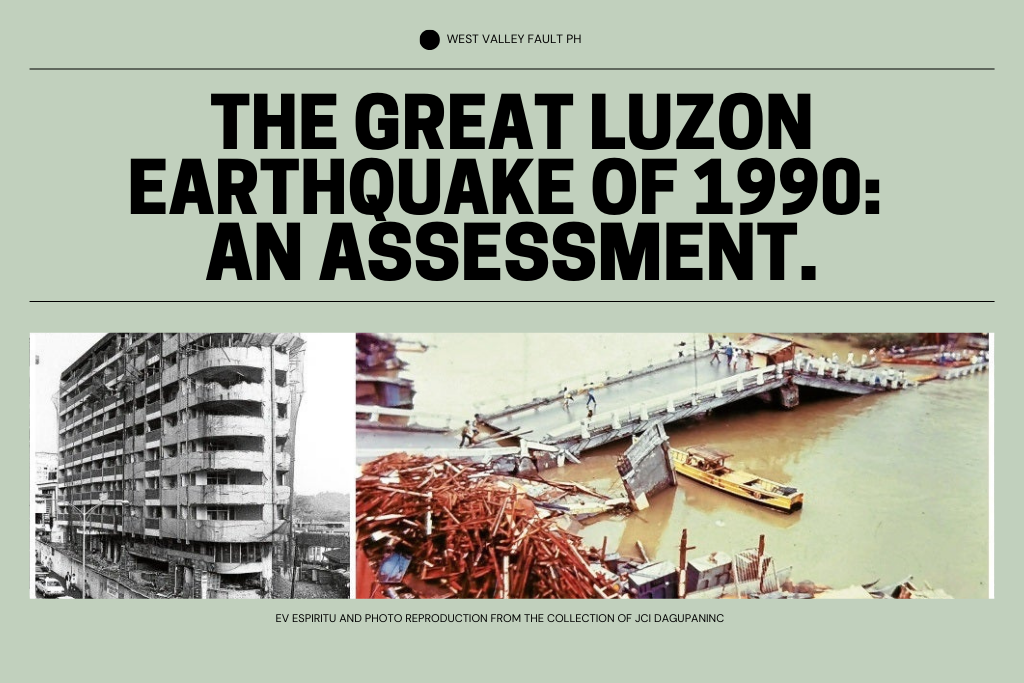
At 4:26 p.m. on July 16, 1990, a magnitude 7.8 earthquake struck northern and central Luzon, producing one of the most destructive Philippine earthquake disasters of the 20th century.
The event—commonly remembered as the 1990 Luzon earthquake—ruptured part of the Philippine Fault–Digdig Fault system. PHIVOLCS documented an approximately 125-kilometer ground rupture extending from Dingalan, Aurora toward Kayapa, Nueva Vizcaya, while severe damage occurred in places including Baguio, Dagupan and Cabanatuan. The disaster remains a major case study in how fault rupture, local ground conditions, building vulnerability, landslides and liquefaction can combine to amplify earthquake losses.
The sections below examine what happened, why some places suffered disproportionately, and which lessons remain relevant to Philippine earthquake preparedness today.
Epicenter and Areas Affected
Epicenter and rupture: PHIVOLCS places the epicenter near Rizal, Nueva Ecija. The earthquake was associated with strike-slip movement along the Philippine Fault–Digdig Fault system and produced an approximately 125-kilometer surface rupture. Severe effects were recorded far beyond the immediate rupture zone, including in Baguio, Dagupan, Cabanatuan and other parts of northern and central Luzon.
Destruction, Landslides and Liquefaction
Destructive force: The earthquake damaged or collapsed buildings, bridges, roads and other infrastructure across a wide area. The scale of loss was shaped not only by the magnitude of the earthquake, but also by local geology, topography, construction quality and the performance of individual structures.
Baguio City suffered some of the most widely remembered building failures, including major hotels and commercial structures. The disaster became an enduring reminder that building vulnerability can determine whether strong shaking becomes a mass-casualty event. WVF’s later Special Report, The Big One Is Not the Biggest Threat—Our Buildings Are, examines that lesson in today’s preparedness context.
In Cabanatuan City, the collapse of the Christian College of the Philippines building became one of the disaster’s most tragic structural failures. The event occurred while the building was occupied, underscoring why earthquake safety depends on structural integrity long before shaking begins.
Landslides: PHIVOLCS documented widespread earthquake-induced landslides in Nueva Ecija, Nueva Vizcaya and Benguet, especially near steep, fractured slopes and areas affected by the ground rupture. Landslides blocked roads, isolated communities and complicated rescue, relief and restoration work.
Liquefaction and settlement: PHIVOLCS documented severe liquefaction and ground settlement in low-lying and water-saturated areas, including parts of Dagupan, Agoo and Aringay, with additional effects reported in Tarlac and localized subsidence in Metro Manila. These ground failures showed why earthquake risk cannot be judged from distance to a fault alone.
Human Toll
Casualties: Historical reports differ in their totals. A PHIVOLCS monograph citing the National Disaster Coordinating Council records 1,283 deaths, 2,786 injuries and 321 missing persons as of November 14, 1990. A separate PHIVOLCS retrospective reports around 1,200 deaths. These are source-specific historical counts. See the PHIVOLCS disaster-response study.

Aftershocks
Aftershocks: A large aftershock sequence followed the main shock. PHIVOLCS deployed temporary seismic stations to study the distribution of aftershocks and the relationship between faulting, site effects and the severe damage observed in places such as Baguio and Agoo. For a major earthquake, continuing aftershocks are an important operational concern because damaged buildings, slopes and lifelines may remain unstable after the main shaking stops.
Economic and Environmental Impact
Economic impact: A PHIVOLCS disaster-response study citing NEDA placed actual damage to public infrastructure, facilities and private property at more than ₱18.7 billion in 1990 values. The economic effects extended far beyond collapsed structures, disrupting transport, utilities, commerce, tourism and public services.
The environmental effects were also substantial. Landslides, debris flows, ground deformation and sediment movement damaged catchments and disrupted roads, rivers, reservoirs and irrigation systems. The 1990 disaster showed that earthquake losses can cascade through natural systems and critical infrastructure long after the initial shaking.
Mount Pinatubo: Examining a Possible Connection
Mount Pinatubo and the 1990 earthquake: The Luzon earthquake occurred less than a year before Mount Pinatubo’s 1991 eruption, which naturally led to questions about whether the two events were connected. Timing alone, however, does not establish causation. The eruption followed a complex sequence of volcanic unrest, magma movement, seismicity and gas emissions, and the 1990 earthquake should not be presented as the cause of the eruption.
The scientifically responsible conclusion is therefore limited: researchers have examined whether large earthquakes can influence volcanic systems, but the historical sequence at Pinatubo does not justify a simple earthquake-caused-the-eruption narrative.
Lessons Learned
Lessons learned: The 1990 Luzon earthquake demonstrated that earthquake losses are produced by more than shaking alone. Structural weakness, landslide-prone terrain, liquefaction, damaged transport links, utility failure and difficulties reaching isolated communities all shaped the disaster. Those lessons remain directly relevant to current preparedness planning.
For households and communities today, the practical lesson is to combine hazard awareness with stronger buildings, realistic evacuation plans, emergency communications and supplies. WVF’s PHIVOLCS hazard-check guide, structural-integrity checklist and Emergency Preparedness Essentials turn those historical lessons into practical steps.
Turn the lessons of 1990 into preparation today.
Build the plan before the next major earthquake

The WVF Family Emergency Planner helps households organize contacts, meeting points, evacuation information, responsibilities and essential records before normal systems are disrupted.
Prefer to start free? Get the WVF Earthquake Preparedness Quick Start Guide, then use Emergency Preparedness Essentials to review water, first aid, lighting, communications, backup power and other household supplies.
Recommended Further Reading
- The Big One Philippines: What Experts Say About the Next Metro Manila Earthquake
- The Big One Is Not the Biggest Threat—Our Buildings Are
- How Close Is Your Home to the West Valley Fault? A Step-by-Step PHIVOLCS Hazard Check
- Is Your Home Fault-Line Ready? A Structural Integrity Checklist for Metro Manila Homeowners
- High-Rise Earthquake Evacuation, Part 1: Before BPO Workers Enter the Stairwell
- Historical Earthquakes in the Philippines
Sources and Primary References
DOST-PHIVOLCS — 1990 July 16 Ms7.8 Luzon Earthquake
DOST-PHIVOLCS — The July 16, 1990 Luzon Earthquake: A Technical Monograph
PHIVOLCS — The 16 July 1990 Luzon Earthquake Ground Rupture
PHIVOLCS — The Main Shock and Aftershock Activity
PHIVOLCS — Organizational Response to the July 1990 Luzon Earthquake Disaster




Leave a Reply