
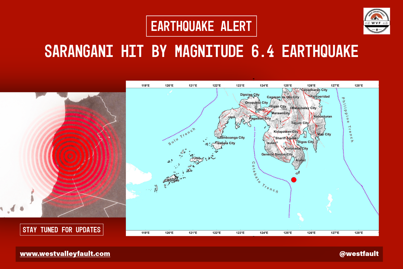
Quick Facts
| Parameter | Details |
|---|---|
| Earthquake Information Number | No. 2 |
| Magnitude | 6.4 |
| Date & Time | 5 Aug 2026 – 14:14:04 PM |
| Epicenter | 37 kilometers SW of Balut Island (Davao Occidental) |
| Depth | 13 kilometers |
| Origin | Tectonic |
| Reported Intensities | I, II, III, IV, V |
| Expected Damage | None |
| Expected Aftershocks | Yes |
| Tsunami Threat | None indicated by PHIVOLCS |
| Bulletin Issue Date | 05 August 2026 – 12:59 PM |
What Happened?
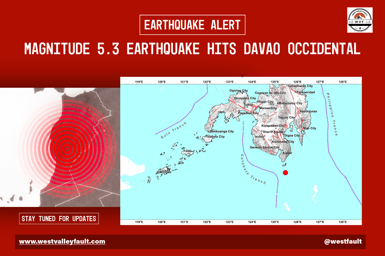
A magnitude 6.4 tectonic earthquake struck Davao Occidental at 12:14 p.m. today, Aug 5, according to the Philippine Institute of Volcanology and Seismology (PHIVOLCS). The earthquake occurred at a depth of 13 kilometers, with its epicenter located 37 kilometers southwest of Balut Island in the Province of Davao Occidental.
Based on the agency’s initial assessment, there were no damage, but aftershocks are to be expected.
At the time of publication, no official reports of casualties or significant structural damage had been released.
Earthquake Details
| Parameter | Value |
|---|---|
| Magnitude | 6.4 |
| Origin | Tectonic |
| Depth | 13 km |
| Epicenter | 37 km SW of Balut Island (Davao Occidental) |
| Coordinates | 05.12°N, 125.26°E |
| Reported Intensities | I, II, III, IV, V |

AI-Assisted Content Disclosure:
The information below was generated with the assistance of artificial intelligence and is provided for general informational and educational purposes only. While every effort has been made to ensure accuracy and clarity, AI-generated content may contain errors, omissions, or interpretations that do not reflect the latest scientific findings or official guidance.
This content should not be considered a definitive or authoritative source for earthquake-related information. Readers are encouraged to verify important details with official agencies such as PHIVOLCS, the Office of Civil Defense (OCD), and other relevant government or scientific institutions before making decisions or taking action.
Always rely on official advisories during emergencies and disaster situations.
What Does Magnitude 6.4 Mean?
A magnitude 6.4 earthquake is classified as a strong earthquake. It is capable of producing strong to very strong ground shaking across a wide area and can cause moderate to significant damage, particularly in communities close to the epicenter and in buildings that are older, poorly constructed, or not designed to modern seismic standards.
Earthquakes of this size can crack or partially collapse vulnerable structures, damage roads and bridges, trigger landslides in mountainous areas, and disrupt essential services such as electricity, communications, and transportation. Well-engineered buildings generally perform much better during a magnitude 6.4 earthquake, although they may still experience non-structural damage such as cracked walls, broken windows, or fallen ceiling materials.
Although a magnitude 6.4 earthquake appears only slightly larger than a magnitude 6.0 event, the difference in energy is substantial. Because the earthquake magnitude scale is logarithmic, a magnitude 6.4 earthquake releases about 16 times more energy than a magnitude 6.0 earthquake. Compared with a magnitude 5.4 earthquake, it releases approximately 32 times more energy.
The overall impact of a magnitude 6.4 earthquake depends on several factors beyond its magnitude, including its depth, distance from populated areas, local ground conditions, and the resilience of nearby buildings and infrastructure. A shallow earthquake occurring beneath or near a populated community is generally capable of producing far greater damage than a deeper earthquake of the same magnitude occurring offshore or in a remote area.
Magnitude 6 earthquakes occur less frequently than magnitude 5 events in the Philippines, but they have a much greater potential to cause damage. When they strike near populated areas, they can become major disasters, highlighting the importance of resilient construction, emergency preparedness, and following official guidance from PHIVOLCS and local authorities.
Why Did This Earthquake Happen?
The Philippines lies within the Pacific Ring of Fire, one of the world’s most active seismic belts. Earthquakes occur frequently as tectonic plates slowly move and interact beneath the Philippine archipelago.
This is a natural geological process and is not related to volcanic activity.
Is There a Tsunami Threat?
Based on the initial PHIVOLCS bulletin, no tsunami warning or advisory was issued for this earthquake.
Most inland earthquakes and many moderate offshore earthquakes do not generate tsunamis. Tsunami warnings are issued only when an earthquake has the characteristics capable of significantly disturbing the seafloor and producing hazardous sea waves.
Residents should always rely on official advisories from PHIVOLCS if an earthquake occurs near the coast.
Could Aftershocks Occur?
If PHIVOLCS indicates aftershocks are expected, residents should anticipate additional earthquakes in the coming hours or days. Aftershocks are a normal part of the earthquake cycle as the Earth’s crust adjusts following the main event.
Most aftershocks are smaller than the main earthquake, although some may still be strong enough to be felt.
Could This Trigger Other Earthquakes?
There is no evidence that this earthquake will trigger a major earthquake elsewhere in the country.
Moderate earthquakes can redistribute stress on nearby faults, but scientists cannot predict whether another earthquake will occur or exactly where it might happen. Each earthquake should be evaluated independently unless geological evidence later establishes a connection.
Key Takeaway
This earthquake serves as another reminder that the Philippines is one of the most seismically active countries in the world. While earthquakes cannot be predicted or prevented, their impacts can be greatly reduced through preparedness, resilient construction, and public awareness.
Residents are encouraged to monitor official updates from PHIVOLCS and local authorities as more information becomes available.
Safety Advice
If you felt the earthquake:
- Be prepared for possible aftershocks.
- Stay away from visibly damaged buildings and structures.
- Check your home for hazards such as gas leaks or damaged electrical wiring.
- Monitor only official information from PHIVOLCS and local disaster authorities.
- Avoid sharing unverified information on social media.
- Remember to Drop, Cover, and Hold On if another strong earthquake occurs.
Don’t Just Read About Earthquakes—Prepare for Them.

Join the WestValleyFault.com community to receive evidence-based earthquake intelligence, practical preparedness guidance, and exclusive Special Reports.
As a welcome gift, you’ll also receive our FREE Earthquake Quick Start Guide.
References
- PHIVOLCS Earthquake Information Bulletin
- DOST-PHIVOLCS Earthquake Monitoring Service









Leave a Reply