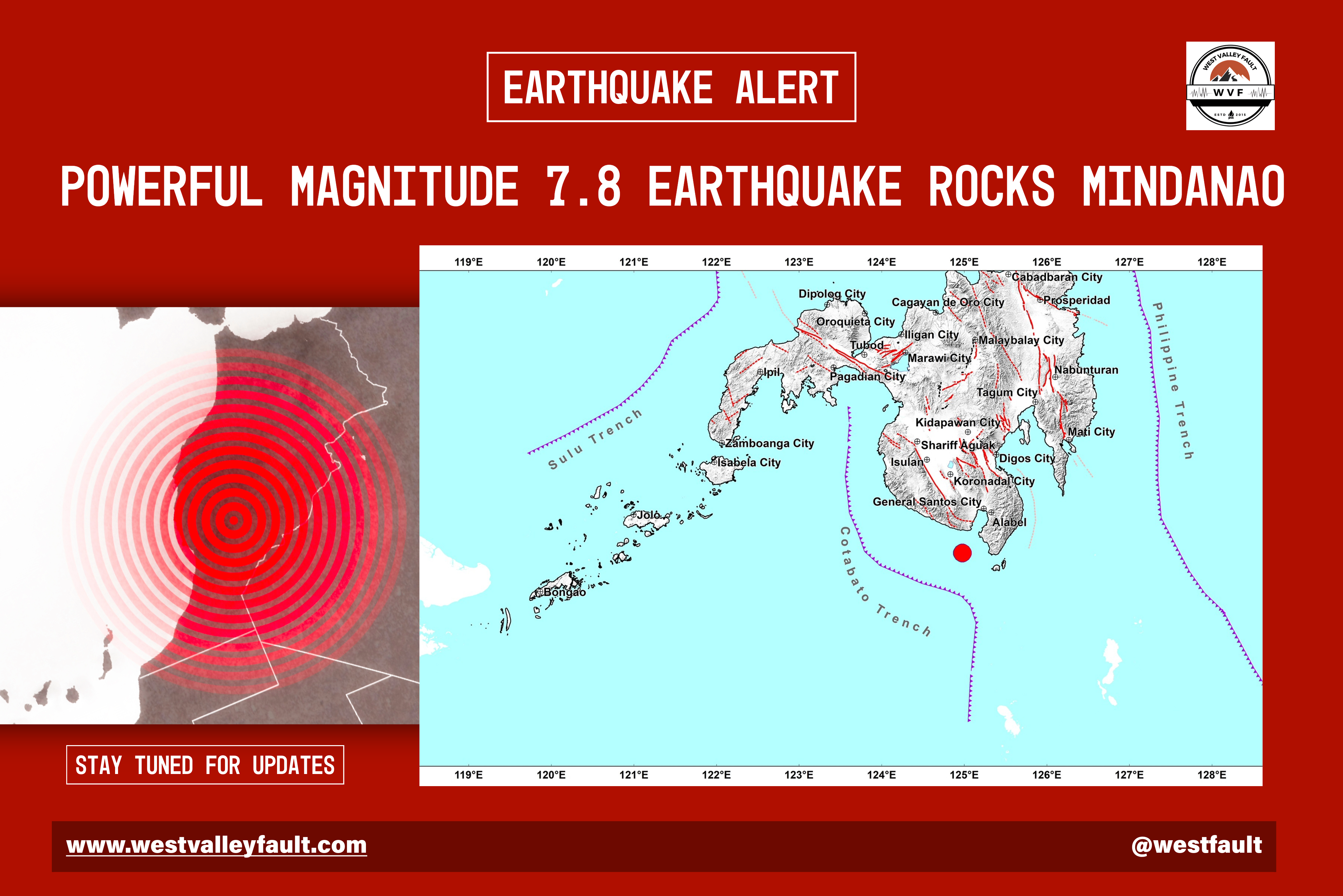
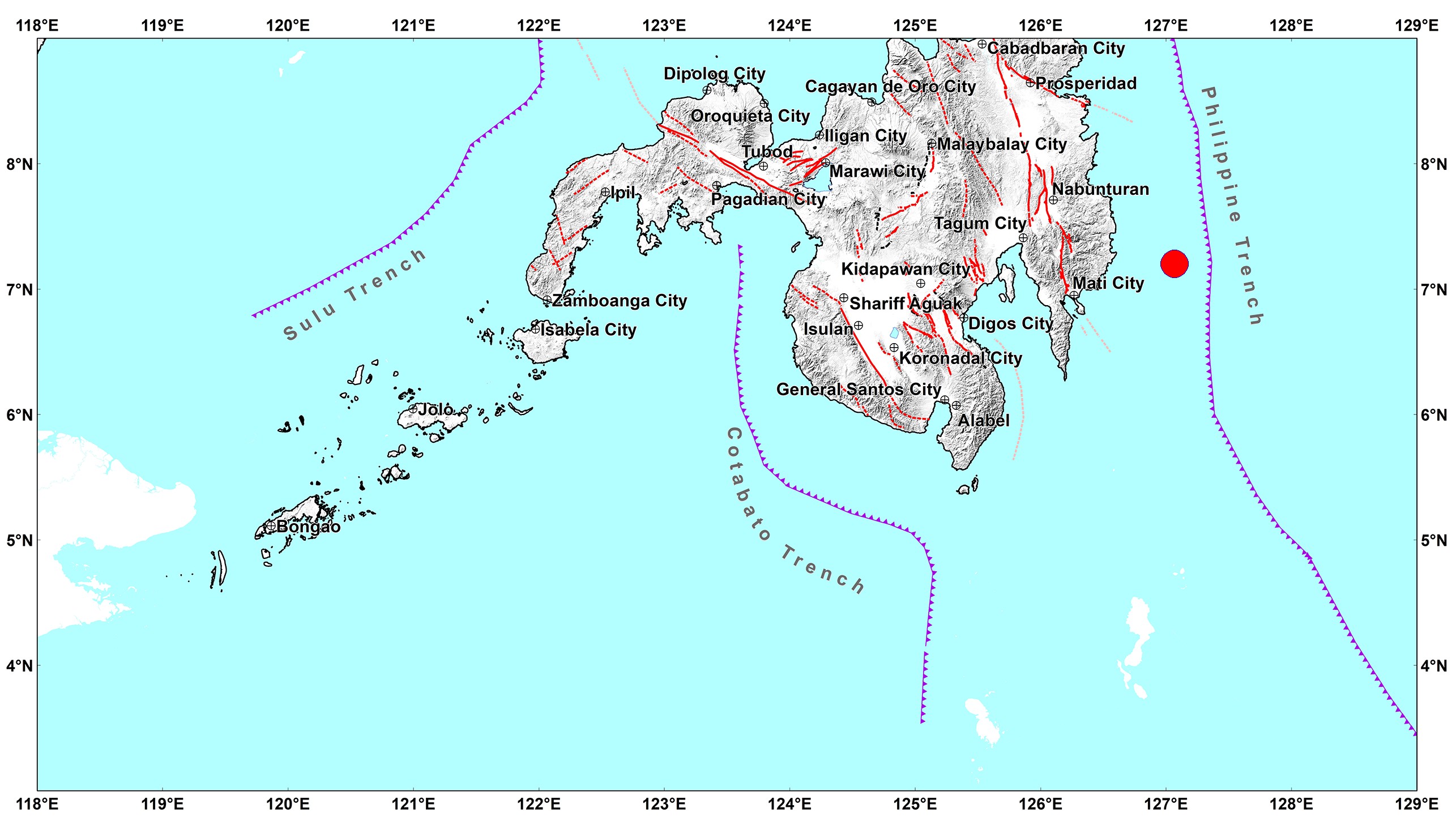
A powerful magnitude 7.8 earthquake struck off the coast of Sarangani early Monday morning, shaking large parts of Mindanao and prompting tsunami warnings across the Philippines and neighboring countries.

Scan the QR code to get this post on the go.
The earthquake struck at approximately 7:37 a.m. Philippine time, with its epicenter located offshore near General Santos City at a relatively shallow depth of about 33 kilometers, resulting in violent ground shaking that was felt across much of southern Mindanao.
Strong Tremors Spark Panic
Residents rushed out of homes, offices, schools, malls, and commercial establishments as buildings swayed for several seconds.
Witnesses described scenes of panic as furniture toppled, televisions and appliances crashed to the floor, and people gathered in open spaces while aftershocks continued throughout the morning. Authorities urged the public to remain calm but vigilant as emergency responders began assessing the affected areas.

Source: PhilStar Global
Buildings Damaged and Commercial Structures Collapse
General Santos City, located closest to the epicenter, suffered some of the most significant structural damage.
Videos circulating on social media showed portions of commercial buildings collapsing, including the upper floor of a Jollibee restaurant and sections of a shopping complex. Churches, office buildings, and residential structures also sustained visible cracks and exterior damage.
In Sarangani province, local officials reported disruptions to electricity and telecommunications services while engineers began inspecting public infrastructure for safety.

General Santos International Airport temporarily suspended operations as authorities conducted runway and terminal inspections to ensure passenger safety before resuming normal activities.
Update
Images of the aftermath posted on Facebook by netizens.


Posts on X.com
Tsunami Warnings Issued Across the Region
Immediately following the quake, the Philippine Institute of Volcanology and Seismology (PHIVOLCS) issued a tsunami warning for coastal communities near the epicenter, advising residents to move inland or to higher ground.
Provinces placed under this warning are:
- Sarangani
- Davao Occidental
- Tawi-Tawi
- Sulu
- Basilan
- Zamboanga del Sur
- Zamboanga Sibugay
- Sultan Kudarat
- South Cotabato
International monitoring agencies also issued alerts for neighboring countries including Indonesia, Malaysia, Japan, Guam, and several Pacific island territories. Forecast models suggested that tsunami waves could reach 1 to 3 meters in some Philippine coastal areas while smaller waves were expected elsewhere in the region.
Small tsunami waves were later recorded in parts of Sarangani and Sultan Kudarat, prompting authorities to keep evacuation orders in place while monitoring sea level changes.

Discover why staying prepared after the initial shaking is just as important as surviving the main quake, and learn the steps every Filipino should take to reduce future risks.
Casualties and Rescue Operations
Emergency responders immediately launched search and rescue operations across affected communities.
Initial official reports indicated no confirmed large-scale casualties, although multiple injuries and incidents of fainting and hyperventilation were reported during evacuations. However, some international media later reported at least one confirmed fatality while local authorities continued verifying additional reports as rescue efforts progressed.
The Philippine Red Cross, local disaster offices, police, firefighters, and medical teams were deployed throughout the region to assist affected residents and inspect damaged structures.
Update:
Reports coming from the Office of Civil Defense already estimated 19 fatalities from the earthquake with 16 of them located in Soccsksargen and 3 others from the Davao Region.
Those injured reached 134 individuals while 7 were declared missing.
Aftershocks Continue
Within minutes of the main earthquake, several aftershocks were recorded, including one exceeding magnitude 6.
PHIVOLCS warned that additional aftershocks capable of causing further damage should be expected over the coming hours and days. Officials advised residents to avoid entering visibly damaged buildings until structural inspections have been completed.

Source: PhilStar Global
Government Response
President Ferdinand Marcos Jr. directed national agencies to coordinate emergency response operations and ordered immediate assessments of critical infrastructure, including bridges, schools, hospitals, airports, and government facilities.
Several local governments suspended classes and advised businesses to inspect their premises before allowing employees and customers to return. Disaster management teams also continued monitoring coastal communities for possible tsunami impacts and additional seismic activity.
These intensities were reported in the following areas:
Intensity VII – CITY OF GENERAL SANTOS
Intensity VI – Palimbang, and Senator Ninoy Aquino, SULTAN KUDARAT
Intensity V – CITY OF DAVAO; City of Kidapawan, and Carmen, COTABATO; Bagumbayan,
Kalamansig, and President Quirino, SULTAN KUDARAT; Sibuco, and Siocon, ZAMBOANGA DEL NORTE
Intensity IV – City of Mati, DAVAO ORIENTAL; Buug, ZAMBOANGA SIBUGAY; Caraga, Manay,
and Tarragona, DAVAO ORIENTAL
Intensity III – CITY OF BUTUAN; Mainit, SURIGAO DEL NORTE; City of Dapitan,
ZAMBOANGA DEL NORTE; Kumalarang, Vincenzo Sagun, ZAMBOANGA DEL SUR
Intensity II – City of Dipolog, Labason, Liloy, President Manuel A. Roxas, and Salug,
ZAMBOANGA DEL NORTE; Alicia, Ipil, Mabuhay, Olutanga, and Siay, ZAMBOANGA SIBUGAY;
Molave, ZAMBOANGA DEL SUR; Abuyog, and Dulag, LEYTE; San Francisco, SOUTHERN LEYTE
One of the Strongest Quakes to Hit Mindanao in Recent Years
The earthquake ranks among the most powerful to strike Mindanao in recent history and serves as another reminder of the Philippines’ location along the Pacific Ring of Fire, one of the world’s most active seismic zones where earthquakes and volcanic activity occur frequently.
Authorities continue to urge the public to:
- Stay away from damaged buildings.
- Expect additional aftershocks.
- Follow official advisories from PHIVOLCS and local disaster management offices.
- Remain in designated safe areas if living near the coast until tsunami warnings are lifted.
Damage assessments and rescue operations remain ongoing as officials work to determine the full extent of the earthquake’s impact across Mindanao.
Sources: PhilStarGlobal, SunStar, GMANewsOnline, Mirror


Leave a Reply