
After an earthquake, a building can remain standing even when the ground beneath it has shifted. Structural inspection alone may not establish whether it is safe to reoccupy when fissures, liquefaction, settlement or slope movement are suspected.
Key Takeaway
A post-earthquake building inspection answers whether a structure shows signs of damage. It does not necessarily answer whether the ground supporting and surrounding that building has remained stable. Where ground effects are suspected, safe reoccupation may require both questions to be considered.
Executive Summary
WestValleyFault.com’s review finds that the Philippines already has substantial ground-assessment capability. DOST-PHIVOLCS maps earthquake hazards, operates the Rapid Earthquake Damage Assessment System (REDAS), investigates ground effects and has demonstrated satellite-based deformation mapping. GeoMapperPH supports field-data collection, while the Mines and Geosciences Bureau (MGB) conducts post-disaster geohazard assessments.
Ground conditions are also already considered in parts of the country’s post-earthquake response. Following the 2025 Northern Cebu and Mindanao earthquakes, the Department of the Interior and Local Government instructed affected local governments to inspect structures affected by ground fissures, sediment venting and subsidence before allowing reoccupation.
The capability already exists and is being used. What is less evident in publicly available national guidance is a single, standardized workflow that routinely connects event-specific ground information to rapid building inspection, specialist referral and reoccupation decisions.
International systems offer models for prioritizing field response: the U.S. Geological Survey estimates where liquefaction and landslides may have occurred, while the European Union’s Copernicus service maps earthquake-related ground movement. Neither replaces on-site assessment.
Why a Building Inspection May Not Tell the Whole Story
Consider a structure that remains upright after strong shaking. Its columns show no obvious major failure. Wall cracks appear primarily non-structural. Doors still open and floors remain generally level.
Outside, however, the evidence may be different. Soil may have settled. A fissure may cross the property. Sand and water may have emerged from the ground. A retaining wall may have shifted. A nearby road may have dropped or moved sideways. A hillside behind the building may contain new tension cracks.
DOST-PHIVOLCS identifies ground rupture, liquefaction and earthquake-induced landslides as earthquake hazards capable of producing fissuring, displacement, sinking or tilting of structures, sand boils and slope failure. Liquefaction can reduce the strength of saturated sediments during strong shaking, while earthquake-triggered landslides can damage structures and leave slopes vulnerable to further movement during aftershocks or prolonged rainfall. These ground effects can compound structural vulnerability—the broader issue examined in WVF’s Special Report on building safety and earthquake casualties.

The post-earthquake safety question therefore has two related but distinct parts: Is the structure safe? And has the site supporting and surrounding it remained stable?
What Ground-Condition Assessment Actually Means
Checking ground conditions does not mean performing soil borings or a full geotechnical investigation at every property after every earthquake. A practical system begins with screening: visible warning signs or event-specific information identify sites that justify specialist assessment, while detailed investigation is reserved for cases where evidence requires it. WVF’s report on Taguig’s soil-mapping initiative illustrates how understanding local ground conditions can inform earthquake preparedness before an event.
- Ground condition is the broad site-safety question: what happened to the land supporting or surrounding a structure?
- Ground failure generally refers to processes such as liquefaction and earthquake-triggered landslides.
- Ground rupture is permanent displacement where fault movement reaches the surface.
- Ground deformation or movement describes measurable displacement of the Earth’s surface and may be detected through field surveying, GNSS or satellite radar.
- Susceptibility mapping identifies areas where a hazard may be possible. It does not establish that the hazard actually occurred during a specific earthquake.
These distinctions matter when maps and observations are used to guide evacuation, inspection or reoccupation decisions.
How Philippine Agencies Assess Post-Earthquake Ground Conditions
The country already possesses many of the scientific and operational components needed for post-earthquake ground assessment.
PHIVOLCS maps the relevant hazards
The PHIVOLCS GeoHazards Portal contains official mapping for ground rupture, liquefaction and earthquake-induced landslides. HazardHunterPH allows users to examine these and other hazards for selected locations. These products provide an important pre-event baseline—answering where ground failure could occur—but they do not confirm what happened during a particular earthquake.
REDAS models earthquake-related ground hazards
PHIVOLCS developed the Rapid Earthquake Damage Assessment System (REDAS) during 2002–2004. It can simulate earthquake hazards including ground shaking, liquefaction, landslides and tsunami, and calculate physical damage, casualties and economic losses. REDAS is not the Philippine equivalent of the USGS Ground Failure product—its functions are broader and its operational model is different—but it demonstrates that earthquake-related ground-hazard modelling capability exists domestically. A separate example of Philippine work on earthquake-triggered slope hazards is WVF’s report on PHIVOLCS and Caraga State University’s earthquake-landslide modelling initiative.
The Philippines can measure earthquake deformation from space
After the July 27, 2022 magnitude 7.0 Northwestern Luzon earthquake, PHIVOLCS used Sentinel-1 satellite images to produce a coseismic interferogram and line-of-sight displacement map. The analysis identified a deformation pattern along the Abra River Fault and measured displacement of approximately 20 centimetres in parts of the affected area along the satellite’s line of sight.
After the September 30, 2025 magnitude 6.9 Northern Cebu earthquake, PHIVOLCS again used Synthetic Aperture Radar analysis to examine the Bogo Bay Fault surface rupture. Its subsequent earthquake poster documented an approximately eight-kilometre onshore rupture, liquefaction in several coastal communities, earthquake-induced landslides, coastal uplift in part of Bogo City and subsidence at Hagnaya Port.
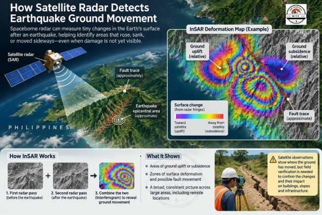
These cases show that Philippine capability extends beyond pre-event susceptibility maps: actual earthquake deformation and ground effects can be observed after an event.
MGB conducts post-disaster ground assessments
Following the Northern Cebu earthquake, MGB deployed geologists for a Post-Disaster Geohazards Assessment, including ground validation and investigation of subsidence, sinkholes and unstable areas. Its reporting documented monitoring for tension cracks, differential settlement, subsiding ground and continuing structural cracks, with findings intended to support local governments, the Office of Civil Defense and housing authorities.
GeoMapperPH provides field-data infrastructure
GeoMapperPH allows national agencies, local governments and partner institutions to collect and update hazard, exposure, vulnerability and disaster information. Its mobile capability can document hazards and disaster events and transfer observations into shared databases. This does not establish that a national earthquake ground-inspection form is in routine use, but it shows that much of the digital infrastructure needed to collect standardized field observations exists.
What Northern Cebu Revealed About Post-Earthquake Ground Safety
Ground condition is not absent from Philippine post-earthquake response. In October 2025, following earthquakes affecting Cebu and Mindanao, DILG directed local governments to conduct rapid assessments before buildings were reoccupied. The instruction specifically included tilted or displaced structures and buildings affected by ground fissures, sediment venting and subsidence.
The Northern Cebu response brought these capabilities into the same emergency: PHIVOLCS documented ground effects, MGB assessed affected sites, and DILG linked visible signs of instability to reoccupation decisions. This demonstrates coordination in a specific response, not proof of a standing nationwide procedure.
The question is whether these components become a routine operating model after future damaging earthquakes.
What appears less standardized
For this report, WestValleyFault.com reviewed publicly available materials from PHIVOLCS, GeoRisk Philippines, DILG, MGB and recent government post-earthquake operations.
| Existing Philippine capability | Evidence |
|---|---|
| Pre-event earthquake ground-hazard mapping | PHIVOLCS GeoHazards Portal and HazardHunterPH |
| Liquefaction and landslide simulation | REDAS |
| Satellite measurement of earthquake deformation | PHIVOLCS SAR/DInSAR products |
| Ground rupture, liquefaction and landslide field investigation | PHIVOLCS Quick Response Teams |
| Post-disaster geological assessment | DENR-MGB |
| Field geospatial data collection | GeoMapperPH |
| Recognition of fissures, subsidence and sediment venting in reoccupation decisions | DILG post-earthquake directive |
| Rapid structural inspection | LGU engineering offices and partner agencies |
The public materials reviewed did not establish one standing national workflow that routinely links event-specific ground-failure screening, exposed buildings and infrastructure, a ground-condition screen during rapid building evaluation, specialist-referral criteria, and a combined building-and-site safety decision where instability is suspected. This does not establish that individual agencies or local governments lack additional internal procedures; only that such an integrated national workflow was not evident in the public materials examined.
WestValleyFault.com finding: The principal opportunity appears to be operational integration, rather than creation of entirely new scientific capability.

Why Hazard Maps Cannot Clear an Individual Property
Pre-earthquake maps identify areas susceptible to ground rupture, liquefaction or earthquake-induced landslides; they cannot confirm what happened beneath a particular foundation during a specific event. WVF’s step-by-step PHIVOLCS hazard-check guide explains how homeowners can use these tools before an earthquake. The distinction between mapped vulnerability and actual site safety also matters in communities with unstable ground, as discussed in WVF’s General Santos ground-stability report.
The same caution applies to rapid regional products. A model may identify where ground failure is more likely; satellite radar may reveal where the surface moved. Neither, by itself, is a parcel-level safety certificate. Site-specific decisions still require appropriate observation and, where warranted, professional assessment.
How International Systems Prioritize Ground-Failure Response
USGS Ground Failure: where should responders look first?
Field teams cannot immediately survey every location affected by a major earthquake. The USGS Ground Failure product combines ground-motion estimates from ShakeMap with susceptibility information to estimate rapidly where earthquake-triggered liquefaction and landslides are more likely to have occurred. Outputs can include estimated hazard, population exposure and regional maps useful for response prioritization.
The operational product has been available since late 2018. USGS research has reported a historical median delivery time of approximately 30 minutes for applicable events, but availability varies and that figure is not a guaranteed response deadline. It does not identify individual ground failures with parcel-level certainty. Its operational value is helping answer: Where should responders look first?
For the Philippines, the transferable lesson is the workflow rather than the specific USGS model: earthquake → shaking estimate → likely ground-failure areas → exposure estimate → prioritized field response.
Copernicus Ground Movement: where did the surface move?
The Copernicus Emergency Management Service introduced ground-deformation monitoring as an earthquake-response capability in 2025. On June 9, 2026, the European Commission’s Joint Research Centre announced that Ground Movement had formally joined the Copernicus Emergency Management Service Rapid Mapping portfolio for earthquake and volcanic activations.
Using Sentinel-1 radar and InSAR, the service can measure surface displacement by comparing compatible pre-event and post-event satellite images. Outputs can include displacement data, maps, movement statistics, affected-area estimates and exposed-population estimates.
The technology has limitations and depends on suitable satellite observations; results can also be affected by factors such as vegetation, atmospheric conditions and viewing geometry. It complements rather than replaces ground observations and field assessment.
| System or assessment | Primary question |
|---|---|
| USGS Ground Failure | Where are earthquake-triggered landslides and liquefaction likely to have occurred? |
| Copernicus Ground Movement | Where has the surface measurably moved, and by approximately how much along the satellite line of sight? |
| Field geological/geotechnical assessment | What happened at this site, and is the condition stable? |
| Structural assessment | Can the building safely continue to perform and be occupied? |
These methods answer different questions: modelling helps prioritize areas, satellite observations reveal surface movement, and field specialists verify site conditions. Their findings can complement structural assessments when authorities evaluate reoccupation.
How Building Inspection and Ground Assessment Could Work Together
The following is a WestValleyFault.com editorial recommendation, not an existing government program or technical standard. The objective is to connect existing capabilities through a tiered operating system, not to require detailed geotechnical investigation at every building.

1. Screen ground conditions at event level
After a qualifying earthquake, PHIVOLCS could combine observed or estimated shaking with existing hazard datasets to identify areas where liquefaction, earthquake-induced landslides, rupture or other ground effects require priority verification. Operational thresholds should be locally developed and calibrated rather than copied directly from another country.
2. Prioritize exposed communities and critical infrastructure
Preliminary ground information could be overlaid with hospitals, schools, evacuation centres, bridges, major roads, water and power systems, telecommunications infrastructure, ports, airports and densely populated communities. The purpose would be to direct limited inspection and specialist resources toward locations where ground failure may have the greatest consequences.
3. Add a site screen to rapid building inspection
Inspectors would not be expected to diagnose complex geological processes. A short ground-condition screen could instead identify observations requiring specialist referral.

The checklist would be a screening tool—not a geological diagnosis.
4. Refer flagged sites and use a two-part safety decision
Sites showing evidence of instability could be referred to PHIVOLCS, MGB, qualified engineering geologists or geotechnical engineers as appropriate. Where ground instability is suspected, unrestricted reoccupation should consider both structural condition and site/ground condition. WVF’s structural integrity checklist for Metro Manila homeowners provides a complementary pre-event framework for recognizing building and site vulnerabilities. Emerging structural-monitoring approaches, such as the Filipino-developed Sentinel building-damage sensor, may offer additional engineering information but do not assess ground stability or replace professional safety inspections. The DILG directive concerning fissures, sediment venting and subsidence provides an operational precedent for connecting the two.
5. Preserve validated observations
Confirmed ground failures could feed into a standardized national geospatial inventory. Each damaging earthquake provides evidence about where liquefaction, rupture, landslides, subsidence and other effects actually occur, improving future hazard maps, modelling, emergency planning and land-use decisions.
For Building Managers: Is Your Workplace Ready Beyond the Inspection?

Post-earthquake building safety involves more than visible structural damage. Facility managers and workplace safety teams can use WVF’s free Workplace Earthquake Readiness Checklist to review evacuation procedures, emergency communications, staff accountability and the follow-up actions that may require qualified professional assessment.
Get your free PDF by email. Enter your address below to request the checklist.
Free PDF. You may also receive relevant WVF preparedness updates. Unsubscribe anytime. This checklist is not a structural safety certification.
What Property Owners Should Watch For After Strong Shaking
For households, the principle is straightforward: a post-earthquake safety check should not stop at the walls. After strong shaking, remain alert to major changes such as:
- newly formed ground cracks;
- sand, water or mud emerging from the soil;
- unusual settlement or sinking;
- buildings, fences or pavements moving out of alignment;
- cracks forming along slopes or retaining walls;
- rockfalls or small landslides;
- ground pulling away from foundations;
- significant changes near rivers, shorelines or embankments.
Report these signs to the appropriate authorities rather than personally investigating hazardous areas. Hazard maps are screening tools and do not replace post-earthquake site assessment.

Do You Know the Ground Hazards Around Your Property?

Ground cracks, liquefaction and slope movement show why earthquake risk extends beyond the walls of a building. WVF’s free Earthquake Risk Checklist for Your Property helps you organize questions about active-fault proximity, ground conditions, building safety and preparedness. It is a preliminary screening resource—not an assessment of post-earthquake occupancy safety.
Get the free property checklist by email. Enter your address below.
Free PDF. You may also receive related WVF preparedness emails. Unsubscribe anytime. The checklist does not replace a geotechnical or structural assessment.
Conclusion: Inspect the Building—and Consider the Ground Beneath It
The evidence points to an operational opportunity: connect ground-failure screening, field observations and specialist referrals to post-earthquake building assessment, so suspected site instability is considered before reoccupation decisions.
rapid ground screening → exposure prioritization → building-and-site observation → specialist referral → occupancy decision
USGS and Copernicus show how regional estimates and satellite observations can help direct attention after a damaging earthquake. The Philippine challenge is to turn relevant ground information into timely, professionally supported decisions about individual sites—not to treat maps or sensor data as safety certificates.
After strong shaking, the question should not end with “Did the building survive?” Where ground-failure evidence exists, responders may also need to ask: “Did the land supporting that building remain safe?”
Prepare Beyond the Headlines

Get WVF’s free Earthquake Preparedness Quick Start Guide and receive practical preparedness updates, explainers and Special Reports by email. A helpful first step for turning lessons from earthquake safety reporting into household preparations.
Get your free Quick Start Guide by email. Sign up below.
Free PDF. You may receive ongoing WVF earthquake preparedness emails. Unsubscribe anytime.
Continue Reading on WestValleyFault.com
How Close Is Your Home to the West Valley Fault? A Step-by-Step PHIVOLCS Hazard Check
A property-level workflow for checking active faults, ground rupture, shaking, liquefaction and earthquake-induced landslide hazards.
The Big One Is Not the Biggest Threat—Our Buildings Are
WestValleyFault.com’s Special Report on structural resilience and the role buildings play in determining earthquake casualties.
Is Your Home Fault-Line Ready? A Structural Integrity Checklist for Metro Manila Homeowners
A practical starting point for examining building and site vulnerability.
Negros Oriental and Siquijor LGUs Begin Seismic-Vulnerability Inventory of Public Buildings
How local governments are identifying public buildings that need closer earthquake-risk assessment.
OCD Western Visayas Urges Landslide Checks After Sibalom Shaking and Heavy Rain Risk
Why unstable ground, slope conditions and post-shaking rainfall risk matter to community safety.
References
- DOST-PHIVOLCS. Earthquake Hazards. PHIVOLCS Earthquake Hazards
- DOST-PHIVOLCS. Earthquake- & Volcano-Related Maps — GeoHazards Portal. PHIVOLCS GeoHazards Portal
- GeoRisk Philippines / DOST-PHIVOLCS. HazardHunterPH — Hazard Assessment at Your Fingertips. HazardHunterPH
- DOST-PHIVOLCS. REDAS Activities / Rapid Earthquake Damage Assessment System. REDAS Activities
- DOST-PHIVOLCS. DOST-PHIVOLCS Launches GeoMapperPH. GeoMapperPH
- DOST-PHIVOLCS. Preliminary Coseismic Interferogram and Line-of-Sight Displacement of the 27 July 2022 M7.0 Northwestern Luzon Earthquake. PHIVOLCS displacement analysis
- DOST-PHIVOLCS. Satellite Image of the Surface Rupture of the Bogo Bay Fault During the 2025 Magnitude 6.9 Northern Cebu. Bogo Bay Fault satellite analysis
- DOST-PHIVOLCS. Poster of the 30 September 2025 Magnitude 6.9 Offshore Northern Cebu Earthquake. Northern Cebu earthquake poster
- Department of the Interior and Local Government / Philippine Information Agency. DILG Orders Immediate Structural Inspections in Earthquake-Hit Areas in Cebu and Mindanao. DILG inspection directive
- Department of the Interior and Local Government / Philippine Information Agency. DILG Urges Immediate Safety Checks on Buildings and Infrastructure Following Southern Mindanao Earthquakes. DILG safety checks
- DENR–Mines and Geosciences Bureau. DENR-MGB Conducts Post-Disaster Geohazards Assessment in Cebu. MGB Cebu assessment
- DENR–Mines and Geosciences Bureau. MGB Geologists Meet with OCD Region 7 and DHSUD Officials for Post-Disaster Geohazards Assessment in Cebu. MGB post-disaster coordination
- U.S. Geological Survey. Ground Failure Scientific Background. USGS Ground Failure
- Allstadt, K.E., et al. The US Geological Survey Ground Failure Product: Near-Real-Time Estimates of Earthquake-Triggered Landslides and Liquefaction. Earthquake Spectra. USGS publication
- Copernicus Emergency Management Service. Rapid Mapping Launches a New Product on “Ground Movement.” June 9, 2026. Copernicus Ground Movement announcement
- Copernicus Emergency Management Service. Ground Deformation Monitoring: A New Earthquake Response Tool. Copernicus ground-deformation monitoring
Appendix A — Sources and Methodology
Purpose and research method
This Special Report reviews Philippine scientific and operational capability to assess post-earthquake ground conditions and considers how those findings may inform building-safety decisions. USGS Ground Failure and the European Union’s Copernicus ground-movement capability serve as international operational references.
The qualitative review draws primarily on official scientific and government materials concerning Philippine hazard mapping, field assessments, post-earthquake response, reoccupation instructions and international ground-failure systems. Principal sources include DOST-PHIVOLCS, DENR-MGB, DILG, USGS and the European Union’s Copernicus Emergency Management Service.
Fact-versus-analysis standard
Statements describing existing systems, agency actions, mapped hazards or observed earthquake effects are based on cited official sources. The conclusion that Philippine capability is partially integrated is a WestValleyFault.com editorial synthesis, not an official government finding or formal audit.
The report does not claim that no internal government procedures exist beyond those reviewed. It states only that the publicly available materials examined did not establish one national workflow requiring event-specific ground screening, mandatory site-condition inspection and combined ground-and-structure clearance for all qualifying post-earthquake assessments.
Technical and cartographic standard
Hazard or susceptibility mapping, event-specific estimation, observed ground failure, measured ground deformation and site-specific safety assessment are distinct categories and should not be presented interchangeably. Any accompanying map should use official PHIVOLCS, GeoRiskPH, DENR-MGB, USGS or Copernicus data as appropriate and identify the source, event and product dates, whether the information represents susceptibility, modelling or observed effects, and major limitations. Regional hazard maps must never be presented as proof that a particular building or parcel is safe or unsafe.
Limitations and editorial note
The original research review relied on publicly accessible documents, official web resources, scientific products and government reporting available through September 25, 2026. The article subsequently received targeted editorial updates through November 8, 2026; these do not represent a comprehensive new audit of all agency procedures or evidence. Some operational procedures may exist internally, locally or in technical documents not available through the reviewed public sources.
The proposed integrated Philippine ground-safety workflow is an independent WestValleyFault.com editorial recommendation. It is not an existing PHIVOLCS, MGB, DILG, DPWH, OCD or NDRRMC program and should not be represented as an official technical standard.
About WestValleyFault.com
WestValleyFault.com is an independent Philippine earthquake-information and preparedness publication focused on evidence-based hazard awareness, resilience and practical preparedness. Its Special Reports synthesize authoritative scientific, technical and government information for public understanding while distinguishing official findings from WestValleyFault.com analysis and recommendations.




Leave a Reply